Baby, It's Gonna Be Cold Outside!
Could We Have a Cold Winter?
I know, it’s only June, but I can’t help dream about a cold winter. So, I’m going to list two reasons below for my prediction that the 2024-2025 winter will be colder than normal. History will be the ultimate judge, but you can decide how persuasive you think my argument is now.
It’s no secret that 4 of the last 5 winters have been milder than normal. In fact, the 2023-2024 meteorological winter (December-February) was the warmest on record with an average temperature of 37.6 degrees (F), which was 5.4 degrees (F) above average. It was also in the top 5 warmest winters on record for 19 states in the Eastern U.S.
Nevertheless, I think most people would agree that Mother Nature often balances things out over time. But watch out when she “squares the ledger.” It’s not always done gradually!
1. Brutal Winters Still Exist.

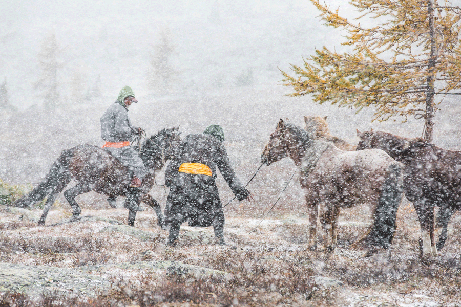
A “dzud” or disaster is a Mongolian term to describe brutally cold, extreme winter weather with excessively high livestock mortality rates. Last year’s dzud in parts of Northeast Asia was among the most severe in 50 years. It featured both a “white dzud,” with exceptionally heavy snow, and an “iron dzud,” which is a brief thaw followed by a rapid, hard freeze that locks pastureland in ice.
There were stretches where night-time temperatures dipped near 58 degrees below zero. Outside the herder’s gers (round, felt-covered tents), the weather was so unforgiving that nearly 5 million livestock perished. A 70-year-old woman said, “I’ve never seen snow that is equal to the height of a ger in my life.”
The fact is that brutal winters still exist. They’re not yet part of folklore.
2. Active Hurricane Seasons Can Be Followed by Severe Winters.
My hypothesis is that active hurricane seasons can be followed by severe winter weather.
Some of the pieces that may help determine an active hurricane season this year are the transition from El Nino to La Nina in the Pacific, along with low wind shear, unusually warm ocean temperatures, and greater depth of warm water in the Atlantic Basin.
Well, NOAA recently issued their highest hurricane season forecast ever. Dr. Phil Klotzbach, a senior research scientist at Colorado State University, seems to agree, saying that “we anticipate a well above-average probability for major hurricanes making landfall along the continental United States coastline.”
Russ Murley and Joe Sciacca from National Weather Forecasting also expect “a well above-average Atlantic hurricane season with high impacts for land masses in the basin.”
Accuweather cautions that “this season, more than others, do not underestimate a hurricane’s potential.” The concern is that rapidly intensifying tropical storms and hurricanes may offer less warning than normal.
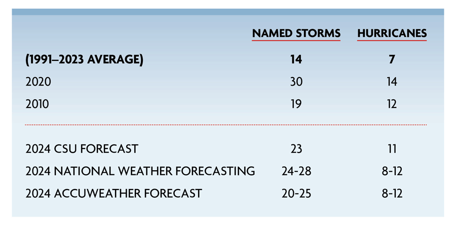
This chart shows the 32-year average number of named storms (14) and hurricanes (7) in bold on the top line below. Compare it to the most active hurricane seasons (2020 & 2010) since 2005 in terms of total named storms and hurricanes. The difference is truly remarkable:

Now, The Million Dollar Question:
What Were The 2020 And 2010 Winters Like?
Winter 2020-2021 was the most significant winter season in many years and the costliest on record. It featured two Nor’easters (December and late January) with blizzard conditions and massive snowstorm totals. It also featured a deadly, polar-vortex induced cold wave in February that impacted nearly every state east of the Rockies with colder than normal temperatures while much-below normal temperatures dominated the entire midsection of the country. Overall, a substantial portion of the country experienced near-average temperatures during the winter period.
Winter 2010-2011, according to NOAA, included a winter with abnormally cold temperatures and abundant moisture which resulted in a historic December-February period in the East and Northeast with numerous snowfall records. For example, Hartford, CT, experienced its snowiest January on record and temperatures for the winter period were 2.4 degrees below the long-term average. The average winter temperature across the continental U.S. was 1.8 degrees (F) below the 20th century average and the 15th coldest on record.
The Skinny
The fact is that brutal winters still exist; they’re not yet part of folklore.
My hypothesis is that severe winter weather in North America can follow an active hurricane season in the Atlantic Basin. And NOAA, as well as many other meteorologists and hurricane experts, are predicting an exceptionally active 2024 hurricane season.
I’m not sure if this June blog will get folks excited (or terrified) about this coming winter, but please be assured that Ray Energy has the knowledge and experience to be well-prepared for everything that Mother Nature sends our way.
Happy Father's Day!
Get Stephen's insights on propane delivered to your inbox every month. Sign up for our monthly newsletter here.
For more frequent updates and industry news, join us on LinkedIn.
NOTE: The views and opinions expressed herein are solely those of the author, unless attributed to a third-party source, and do not necessarily reflect the views of Ray Energy Corp, its affiliates, or its employees. The information set forth herein has been obtained or derived from sources believed by the author to be reliable. However, the author does not make any representation or warranty, express or implied, as to the information’s accuracy or completeness, nor does the author recommend that the attached information serve as the basis of any buying decision and it has been provided to you solely for informational purposes.
© 2011-2024 Ray Energy Corp. All rights reserved. Any reproduction, representation, adaptation, translation, and/or transformation, in whole or in part by whatsoever process, of this site or of one or several of its components, is forbidden without the express written authorization from Ray Energy Corp.

